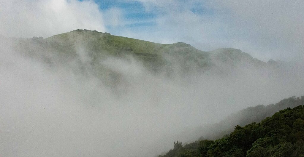
Chikmagalur is a hill station that sits at 3400 ft amidst the greenery-filled western ghats of Karnataka. With misty mountains, lush green forests, dashing meadows, mesmerizing waterfalls, wandering streams, vibrant valleys, brimming coffee plantations, and serene environment this place is sure to take your breath away with its beauty. In fact, these variations in the landscape are the sole factor that attracts thousands of trekkers, nature lovers, adventure freaks, shutterbugs, and travelers to this land. Apart from this, you can also find a wide range of wildlife in this area.
Interestingly, this place was given as a dowry to Rukmangada the younger daughter of the chief of Sakleshpura. Hence, this place is called “Chikmagalur ” which means “younger daughter “ in regional language Kannada.
It is home to coffee plantations that produce best aromatic coffees, hence it is popularly known as” Coffee Land of Karnataka”.Not just that, the Coffee crop was 1st grown 1670 AD in Baba Budangiri range of Chikmagalur in the whole of India. Saint Baba Budangiri during his pilgrimage tour to Mecca and Yemen, collected various coffee bean and planted it in Bababudangiri.
Besides this, as of now, Chikmagalur is the largest producer of Coffee in the country.
If you are a hardcore coffee fan, then do not forget to sip on some hot cup of flavorsome coffees.
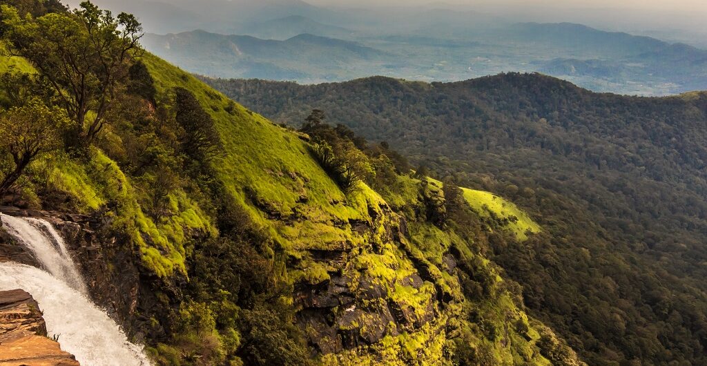
Ballalarayana Durga is a fort that is tucked up on the mountain amidst the western ghats region of Chikmagalur. The vantage point at 1509 meters above sea level, hosts the best panoramic view of Valley, streams, and rolling misty mountains. Above all, when you are here, you can literally walk through the moist clouds and experience it. However, be prepared to undertake an intense trek through the dense forests and grasslands to reach the fort. As you step into the fort area, you will be able to notice a blend of mystery and history prevailing even till date. You can see a small byre at the center and a fort wall which is built kilometers together across the edge of the hills. Besides this, just settle down comfortably on the outer wall of the fort and watch the golden hues of the Sun running down the horizon and creating a magical aura in nature Ballalarayana hills were home to a majestic fort built by the wife of Veera Ballala 1 of the Hoysala Dynasty. This fort was built in the Karnata Dravida style of architecture during the 12th century. It has a rich history and cultural significance attached to it. However, as of now only the ruins of fort i.e. shattered walls, a few arches, and a basement remains. Avoid pitching a tent near the fort as the place is windy and most part of the land has hard soil. Apart from this, the fort is also home to cattle that attract leopards. Instead, you can camp near Bandaje Arbi falls which is considered safe. But be prepared to trek for another 5 Kilometers through grasslands to reach the waterfall. Ballalarayana Durga Fort Trek Route Trek starts near the Kalabhairaveshwara temple at the foothill of the fort in Durgadahalli. It
Ballalarayana Durga is a fort that is tucked up on the mountain amidst the western ghats region of Chikmagalur. The vantage point at 1509 meters above sea level, hosts the best panoramic view of Valley, streams, and rolling misty mountains. Above all, when you are here, you can literally walk through the moist clouds and Read More
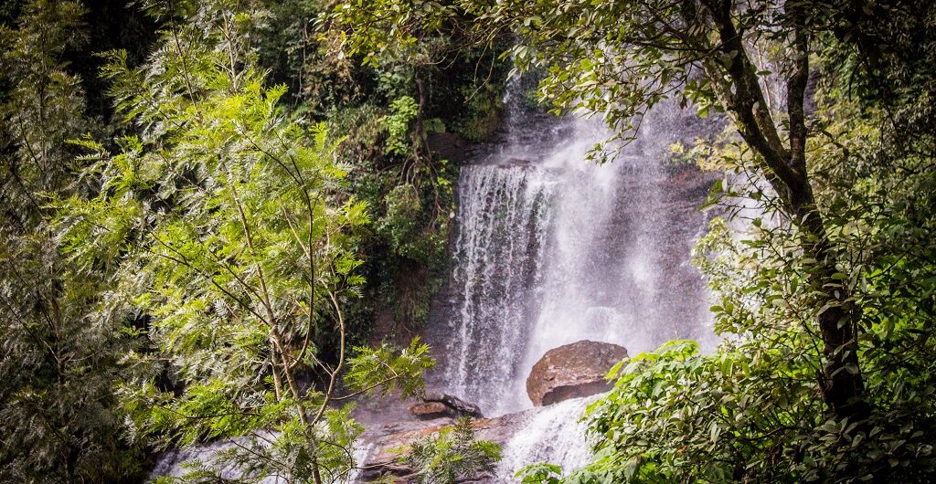
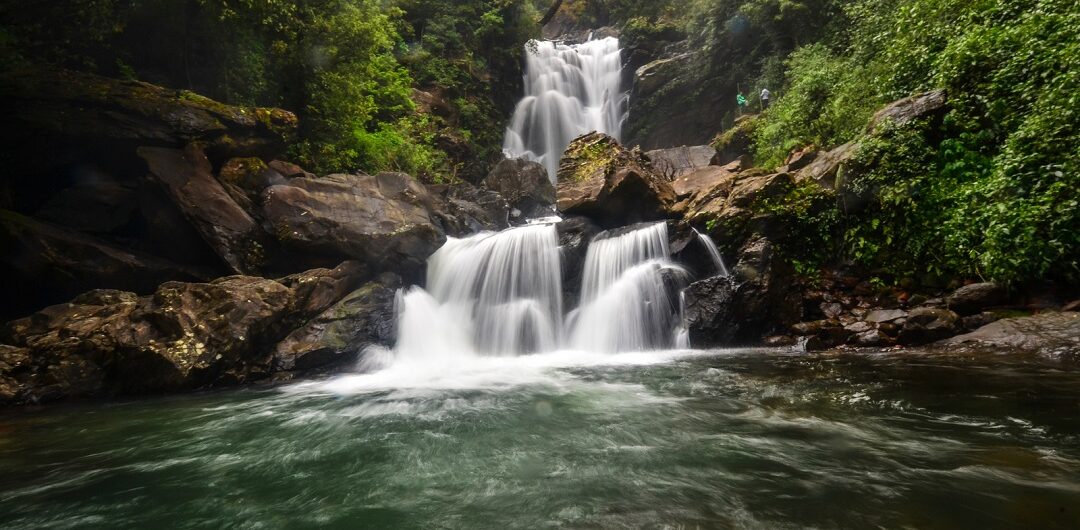
Bandaje Arbi is a hidden waterfall on top of a mountain, amidst the blanket of greenery surrounding it. This waterfall which is a tributary of the Netravati river is situated in Charmadi ghat range of western ghats in Dakshina Kannada. Usually, we will be witnessing the water plunging down from the foothills or from another hillock. However, in this case, you get a chance to stand next to the point from where the water jumps off the cliff from 200ft. The only way to experience Bandaje Arbi falls beauty is by undertaking a hard day's trek to the mountains. Be prepared for a tough and sweaty trek through dense forest, tall grasslands, and multiple streams. Don’t miss the dramatic view of sunsets that cast an orange glow in the sky, from the tip of the cliff. You can camp overnight next to the waterfalls and gaze at billions of twinkling stars throughout the night. Try reaching the spot before sunset and pitch your tents on flatlands next to waterfalls. Also, collect firewoods to light the bonfire for cooking purposes as well as to keep wild animals away from camp. Above all, you can even take a shower by jumping into the Bandaje stream that originates here. Although the place is a little clumsy and hard to stand comfortably. Even though the cliff is far from this spot, be careful as small slips can drag you along the stream and toss you off the cliff. By the way, if you are wondering what Bandaje Arbi means. Bandaje is the name of the village and the word “Arbi” in regional Tulu language means “Waterfall”. Bandaje Arbi Falls Trek Routes Before you start your trek, you need to seek permission from the Belthangady forest authorities. It is a remote area with the paths
Bandaje Arbi is a hidden waterfall on top of a mountain, amidst the blanket of greenery surrounding it. This waterfall which is a tributary of the Netravati river is situated in Charmadi ghat range of western ghats in Dakshina Kannada. Usually, we will be witnessing the water plunging down from the foothills or from another Read More
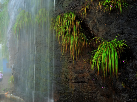
Jhari Falls is a 2 tier waterfall that is tucked within the dense forests and coffee Plantations of Western Ghats. Silky water tumbles down the natural step-like structure formed by rocks from a height of 50 to 70 m. The spring that originates on top of the mountains flows down as the Jhari falls. A tiny natural pool at the bottom of the falls is well suited to play around and relax to beat the heat. Moreover, if you are an Adventure Junky then try to head to the 2nd tier of the waterfall, which is 30 meters above. To reach the 2nd tier, you can take a muddy path that runs parallel to the wall of the falls. This is a little tricky path, hence you will not find many people attempting it. When you look at these waterfalls from close quarters, it appears like a thin line of water cascading down, hence it is popularly known as” Buttermilk Falls”.Locals here refer to this waterfall as “Dabdabe Falls” so don’t get confused, when you hear that name..This is one of the popular waterfalls in the close proximity of Chikmagalur and visited by thousands of travelers every year. Jhari Falls Trek As this waterfall is hooked in one corner of a coffee plantation, be prepared to hike for 3 kilometers from the parking lot. Steep muddy road amidst lush green forest and aromatic coffee plantations will lead you to the foot of Jhari falls. If you don’t want to put your legs to use, then hire a jeep for an adventurous ride to waterfalls. However, if you want more thrill in life, then ride your bikes on uneven and slippery jeep trails. Mullayanagiri Peak To Jhari waterfalls Trek Via Kavikal Gundi Checkpoint You can witness a lot of travelers trekking
Jhari Falls is a 2 tier waterfall that is tucked within the dense forests and coffee Plantations of Western Ghats. Silky water tumbles down the natural step-like structure formed by rocks from a height of 50 to 70 m. The spring that originates on top of the mountains flows down as the Jhari falls. A Read More
Manikyadhara falls is a small perennial waterfall surrounded by Shola forest in the Baba Budangiri range of western ghats. Water tumbles down the mountains from 30 ft height and appears like a string of pearls before hitting the ground. Hence, this falls is called “Manikyadhara” which literally translates to “pearls” in the regional language Kannada. Manikyadhara is also known as “ Neelikayi Theertha” by locals for the same reason as above. Not just waterfall, the place itself looks great with misty Baba Budangiri hills, steep valleys with a lot of trees, tiny streams meandering around, and the cool breeze blowing at you makes it all the more exciting. Manikyadhara falls is just 3 Km from Datta Peetha hills or Baba Budangiri hills. Usually, you can spot a lot of trekkers hiking from Datta Peeta through scenic mountains and forests for reaching the falls. After you reach the falls, you need to take the well-laid steps to reach the bottom of the falls to enjoy nature to the fullest. You can set up your tents on the open grounds near the Manikyadhara falls.No need to worry about the foods as there are many eateries and shops near the falls. Story Of Manikyadhara Falls There is a small story as to how this waterfall originated. Apparently, it is believed that Saint Baba Budan along with his 4 disciples were searching for water and were upset because they weren’t able to find one. Therefore, they prayed to God and within no time, water started pouring down from mountains and that turned out to be Manikyadhara falls. Hence, this place also acts as a Holy place for many. Apart from this, there is another blind belief i.e. if you leave any of the things here, all your wishes will be fulfilled. If fact, you
Manikyadhara falls is a small perennial waterfall surrounded by Shola forest in the Baba Budangiri range of western ghats. Water tumbles down the mountains from 30 ft height and appears like a string of pearls before hitting the ground. Hence, this falls is called “Manikyadhara” which literally translates to “pearls” in the regional language Kannada. Read More
Untouched beauty Hanumangundi falls that is stuck amidst western ghats is only 15 km from Kudremukh National Park. Also popularly known as Suthanabbi falls among locals, this falls is surrounded by lush green forests and hilly terrains, Hanumangundi falls slides down bouncing on the rocks that appear like uneven steps from 100 ft to reach the ground. At the touchdown of the Hanumangundi falls, a tiny pool is formed which is not very deep. Hence, it is an absolutely safe and fun place to swim around as the water gushing out directly falls on you You can spot this falls located between Lakshya dam and Karkala in Mangalore- Sholapur Highway. In spite of being next to the highway and a small board indicating the falls, you might miss out on the spot, so be watchful and never take your eye off the road. You need to take a short walk from the main road before taking 300 odd steps near the forest department to reach the bottom of the falls. Be prepared to jump across a few small rocky and slippery boulders before you reach the tiny pool. Furthermore, don’t forget to carry your own food as you will hardly find any eateries in the nearby surroundings. Undoubtedly, one of the serene waterfalls with not much of a crowd and best place to take a dip in chilled water and have me-time. Hanumangundi Falls information Entry Fee: Rs 40/ person. Timings:9 Am to 5 Pm. Best Time To Visit: June To February. Distance From Bangalore: 350 Km. Also, read: Kudlu Theertha Falls.
Untouched beauty Hanumangundi falls that is stuck amidst western ghats is only 15 km from Kudremukh National Park. Also popularly known as Suthanabbi falls among locals, this falls is surrounded by lush green forests and hilly terrains, Hanumangundi falls slides down bouncing on the rocks that appear like uneven steps from 100 ft to reach Read More