

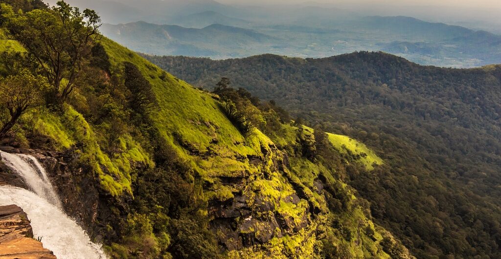
Bandaje Arbi is a hidden waterfall on top of a mountain, amidst the blanket of greenery surrounding it. This waterfall which is a tributary of the Netravati river is situated in Charmadi ghat range of western ghats in Dakshina Kannada. Usually, we will be witnessing the water plunging down from the foothills or from another hillock. However, in this case, you get a chance to stand next to the point from where the water jumps off the cliff from 200ft. The only way to experience Bandaje Arbi falls beauty is by undertaking a hard day’s trek to the mountains. Be prepared for a tough and sweaty trek through dense forest, tall grasslands, and multiple streams. Don’t miss the dramatic view of sunsets that cast an orange glow in the sky, from the tip of the cliff.
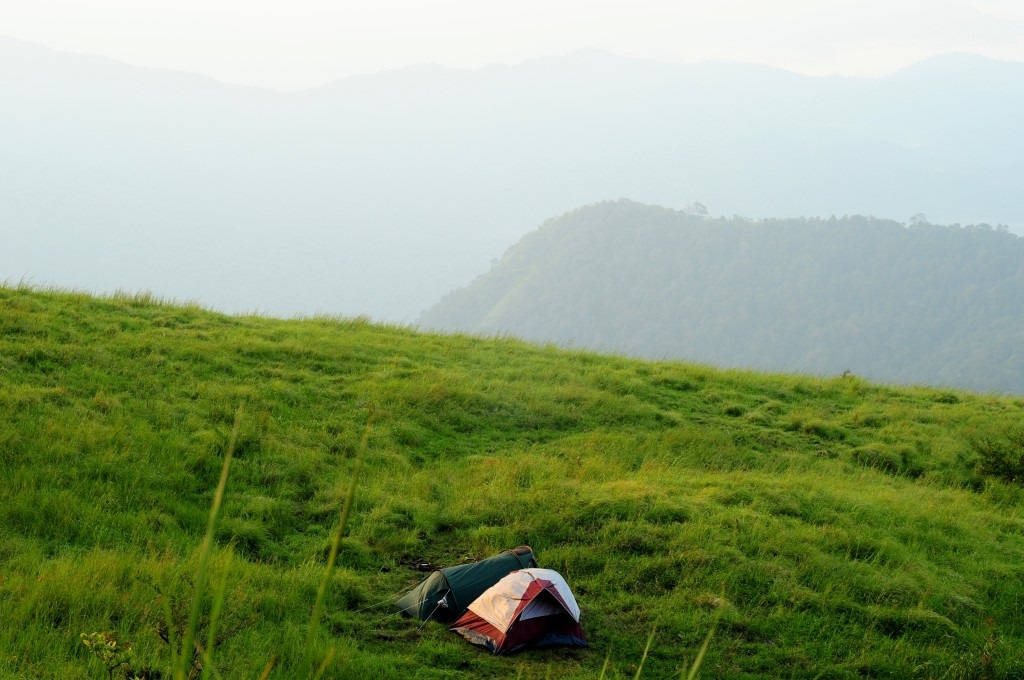
You can camp overnight next to the waterfalls and gaze at billions of twinkling stars throughout the night. Try reaching the spot before sunset and pitch your tents on flatlands next to waterfalls. Also, collect firewoods to light the bonfire for cooking purposes as well as to keep wild animals away from camp.
Above all, you can even take a shower by jumping into the Bandaje stream that originates here. Although the place is a little clumsy and hard to stand comfortably. Even though the cliff is far from this spot, be careful as small slips can drag you along the stream and toss you off the cliff.
By the way, if you are wondering what Bandaje Arbi means. Bandaje is the name of the village and the word “Arbi” in regional Tulu language means “Waterfall”.
Table of Contents
Bandaje Arbi Falls Trek Routes
Before you start your trek, you need to seek permission from the Belthangady forest authorities. It is a remote area with the paths that are confusing and in the recent past a lot of people lost their way into the wild, Hence, you will be allotted a local guide who will be guiding you throughout the trek.
Trek Trail 1: From Gowdara Mane Bandaje Village(Ujire Side)
Ujire Town( jeep ride)-( 15 Km)->Gowdara Mane in Bandaje Village(Trek start point) -9Km (5 To 6 hrs)->Bandaje Arbi Falls(Camping) -6Km (2 To 3 hrs)->Ballalarayana Durga Fort -4Km(1 hr)->Durgadahalli( Trek End Point)
Trek starts from Bandaje Gowdara Mane or Valambra after taking permission from forest officers. It is about a 20 km trek and might take around 10 hrs to complete it in a single stretch.
From Gowdara Mane to Grasslands
To begin with, you will be passing through a village and a couple of small streams. In the initial phase, as you are entering the forest it will be very difficult to find the route without the local guide. Once you cross the 2nd stream, the trek gets tougher as .you enter the dense forest that is steep and full of leeches. After about 1.5 hours of a hard trek journey, you will come across a big stream. Be careful while crossing this stream during peak monsoon, when the currents are high. Don’t forget to fill in your water bottles, as the next water source is waterfalls itself. Another 1.5 hours of trek inside the forest will lead you to grasslands.
Grasslands To Bandaje Arbi Falls
After a few minutes of walking on the grasslands, you will get the 1st glimpse of Bandaje Arbi Falls. However, it will take another hour to reach the waterfall, considering the steepness and campings gear you are carrying. Try drinking water and apply sunscreen lotion to defend or protect yourself against the heat of the scorching sun. The entrance of waterfalls is towards the left. But, you have to cross a small valley which is steep and has loose soil to reach the Waterfall. To get to the tip of the cliff you need to cross Bandaje stream. There are flatlands near the stream, where you can pitch a tent to stay overnight.
Note: Don’t go to the edge of the cliff, as many people have slipped off the cliff and lost their life.
You can descend in the same route as you climbed or via the Ballalarayana Durga fort
Bandaje Arbi Falls To Ballalarayana Durga Fort
It is a 6 km trek from waterfall to the fort and it might take 2 to 3 hours to complete. Trek is mostly through the grasslands and the path is well marked. Try filling your water bottles before you depart, as there are no water sources. Strolling on the left side of Bandaje Arbi waterfall will lead you to the fort.
Initially, you have to climb a steep hillock for 30 odd minutes. Later, you will be hiking on almost flatland through the meadows for another 1.5 hrs before you arrive at the fort. Not to mention, the beautiful panoramic view of valleys, green rolling mountains, and misty surroundings that are breathtaking while on this route.
The fort is now in ruins, you can’t find anything except for shattered walls, a few arches, and a basement. The most important thing, don’t camp near the fort, as this place is home to cattle that attract leopards.
Ballaladurga Fort to Durgadahalli
This is probably one of the easiest paths of the Bandaje Arbi Falls trek. Descend down is a well-marked path through grasslands and forests. On the way, you will come across 3 small water streams that will help to quench your thirst. It is a 4 km descent and it will take about 1 hour to reach the base. In the meanwhile, you can call auto-rickshaw driver number mentioned on the rocks to pick u up and drop in Sunkasale which is 5 km.
Trek Trail 2: From Durgadahalli (Sunkasale side)
You will be starting your trek from Durgadahalli Base from the Sunkasale side. The route is easy and well marked. You might not require a guide unless you are getting down from the other side. This route is exactly opposite to that of trek trail 1 or Ujire side of trekking.
Sunkasale Town( jeep ride)-(5 Km)->Durgadahalli(Trek start point)-4Km(2 hr)->Ballalarayana Durga Fort -6Km (2 To 3 hrs)-> Bandaje Arbi Falls(Camping) -9Km ( 4 hrs)-> Gowdara Mane in Bandaje Village(Trek End Point))
Where To Eat Near Bandaje Arbi Falls
Except for a few small eateries and shops at the base, you will not have anything on the top. Hence, try carrying packed lunch, snacks, and water bottles to fill water in streams. If you are planning to cook, take small vessels, Maggie, and raw materials that can be cooked easily on firewood. You can pack your lunch in Gowdara mane or from the hotel in Ujire.
How To reach Bandaje Arbi Falls Trek Start Point
Trek Trail 1 start point: Bandaje Gowdra mane
Bandaje Gowdra mane or Valambra town is just 15 Km from Ujire town near Dharmastala. You have to take a left turn before Mundaje village and continue for 5 Kilometers before taking a right turn near co-operative bank Hedya in Bandaje road to reach Valambra. The frequency of government buses or private buses in this route is very less. Hence, it is better to hire a jeep from Ujire or take your vehicle till the Bandaje Gowdra mane which is the starting point of the trek.
Trek Trail 2 start point: Durgadahalli Base Point
You can hop into frequently available buses from Bangalore to Horanadu. From Horanadu you can take a local bus or jeep to Sunkasale which is 30 Km away. From Sunkasale you can either walk or hire an auto-rickshaw to Durgadahalli which is the start point of freak.
Bandaje Arbi Waterfalls Information
Entry Fee: Rs 275/ head
Guide Charges: Rs 1000 To 1500(Try Bargaining)
Banjare Arbi Waterfall Trek Distance: 18 To 20 Km
Trek Duration: 8 To 10 Hours:
Difficulty Level: Moderate
Best Time To Visit: September to March
Permission: Required
Camping: Allowed Near Bandaje Arbi Waterfalls
Location: Bandaje Village 20 Km From Ujire Town, Dakshina Kannada
Distance From Bangalore: 320 Km.
Bandaje Arbi Waterfalls Trek, Contact Details That Might Be Handy
Gowdara Mane Or Kishore Gowda: 99019 39829
Forest Officer: 99013 46952
Belthangady Forest Office: 08256-233189
Also, read: Ermai Falls Trek.
Comments